Introduction to Wittgenstein
Background
This page is meant as an introduction to the formerly independent County (Grafschaft) of Wittgenstein for the benefit of the American reader. It was in Wittgenstein that the Riedesel name appeared around 1600 (if not earlier) and from which almost all American Riedesels descend as do all but a few Germans by the name.
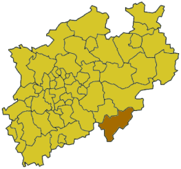
State of North Rhine-Westphalia, with Siegen-Wittgenstein in the darker color.
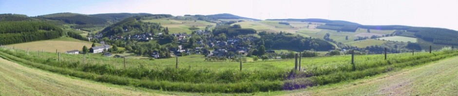
Wittgenstein no longer exists as a political entity. The district by that name was joined to another to form what is now the Kreis (district) of Siegen-Wittgenstein in the federal Land(state) of Nordrhein-Westfalen (North Rhine-Westphalia). However, three towns within the district–Bad Berleburg, Bad Laasphe, and Erndtebrück–include almost all of the historical territory of Wittgenstein. The villages, hamlets and individual houses “out in the country” technically belong to one of the towns. Residents still identify strongly as Wittgensteiners.
Contents
Location
Political History
Social History
Towns, Villages, Places
Maps
Links
Location
Wittgenstein lies east of the great city of Köln (Cologne) and north and slightly west of Frankfurt. It is a mountainous area and relatively isolated. The district of Wittgenstein was less than 500 square kilometers or less than 200 square miles in size as of its 1974 combination with Siegen.
Geographically, Wittgenstein lies at the southern tip of the Sauerland in west central Germany. The mountains are called the Rothaargebirge, or “red-hair mountains.” It is one of the most-densely wooded area of Germany. At its north is Kahler Asten, the tallest peak in central Germany with a height of 2759 feet.
The Rothaargebirge are an important boundary in several respects. They once separately the Saxon and Frankish tribes, with the Wittgensteiners being primarily Frankish. They are part of the dividing line between low German dialects and the middle German dialects such as that spoken in Wittgenstein. They are also the dividing line between predominantly Catholic Westphalia and Protestant areas extending to the south and east.
The Eder and Lahn rivers originate near and pass through Wittgenstein, and numerous smaller streams flow through the valleys. The Elsoff and Odeborn are the most important of these smaller streams.
Return to top
Political History
Human settlement dates back to 700 B.C. and earlier, though the archeological evidence is slim. Celts and later Chatten (a Germanic tribe) lived in the area, but the area may have lacked permanent settlement for several centuries due to climate change. Recorded history begins around 800 at the time of Charlemagne. By 1200, it had begun to take the form of a Grafschaft, the best translation of which is County.
A Graf or Count was in theory an administrator of an area for the Emperor, but in reality these officials strove to become hereditary rulers. We will not attempt to explain the complex and often chaotic system of early feudalism. The family name of the first Counts came to be rendered as Wittgenstein. In 1381 the male line came to an end, but through marriage with another family became Sayn-Wittgenstein. That remains the proper name of the ruling family to this day (Sayn rhymes with “mine”). Nevertheless, the area continued to be called just Wittgenstein.
More or less continuously since 1511, Wittgenstein was split into southern and northern parts. The first pair of brothers feuded and relations between cousins in later centuries varied from warm to lukewarm, but their fates were intertwined. The southern branch had its seat in the older town of Laasphe and was known as Wittgenstein-Wittgenstein (don’t ask), while the northern branch had its seat in the poorer town of Berleburg and was known as Wittgenstein-Berleburg.
The original state of Wittgenstein and then the twin counties were members of the Holy Roman Empire of the German Nation. This meant that they were officially independent and autonomous. The Sayn-Wittgensteins could and did take on feudal obligations from larger states, but they had primary legal authority in their realm. For the first centuries of their rule, the Sayn-Wittgensteins faced certain other powers, and their subjects claimed certain ancient political and economic rights. The latter faded with the rise of what historians call princely absolutism.
The dreadful Thirty Years War (1618-1648) may have begun in Bohemia, but ravaged much of central Europe. Wittgenstein was not spared. In the relative peace that followed, the surviving rulers claimed ever greater authority over all aspects of life. Independent farmers or free men were virtually non-existent in Wittgenstein. A few of the ruling line, notably Graf Casimir (1687-1741), attempted to rule as enlightened despots, but they commanded an ever-increasing amount taxes and labor service from their subjects. They regulated how long a wedding festival could last and who could be invited. They set wages. They appointed the pastors. They charged a fee to anyone wishing to leave.
Not unlike many other small princes in the German states, the world of the Sayn-Wittgensteins came to an end with Napoleon’s conquest of the Rhineland. Wittgenstein was incorporated into the French-run “Grand Duchy of Hesse” in 1806 and remained there through the Congress of Vienna in 1815. Like all empires, the French looted their new territories and pressed its sons into fighting its next campaigns.
The victorious powers set out to reverse Napoleon’s dismantling of the aristocratic order, but did so to the advantage of the larger states. What had been more than 300 often-tiny states (such as Wittgenstein) emerged from the Congress of Vienna as a few dozen larger ones. Wittgenstein became part of the powerful state of Prussia, assigned eventually to the province of Westfalen. While the Sayn-Wittgensteins no longer had political sway, their palaces and land (valuable forests) remained their own. Just before the French moved in, the Emperor had elevated them from Counts to Princes.
The Prussian inspector sent to check out this new territory was astonished at the tax and labor burden carried by the peasants, but the King/Emperor just added more. One right the common people did gain was to purchase the lands they had worked (often for centuries) from the Sayn-Wittgensteins. Feudal labor services finally came to an end. They were also free to emigrate, as many did throughout the 1800s. When asked their nationality, these emigrants would correctly say “Prussian”, at least until 1871 when a unified German state under the rule of the King of Prussia emerged after Bismarck’s wars.
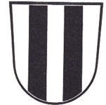
Simple Wappen (arms) of the
district of Wittgenstein
A district called Wittgenstein survived until 1974. Villages such as Wunderthausen had their own Bürgermeister and a limited amount of local political authority. What happened in 1974 was an extensive re-organization of the political structure of the entire country. It was then that Wittgenstein became part of a larger district, first called just Siegen and only later named Siegen-Wittgenstein.
Return to top
Social History
Most people in Wittgenstein were small subsistence farmers. Some of the scarce arable land was owned outright while other land was controlled by the Count. The balance of independent property vs. tenant land shifted toward the latter with the rise of princely absolutism. Full-time craftsmen were rare, even in the towns. The peasant farmer (Bauer) had little to exchange, and coinage was scarce. The only meaningful export was wood and later charcoal for the steel mills in Siegen or elsewhere. Making the latter was dirty, tedious work. Transporting anything out (or in) was difficult.
Industry began to develop in the towns by the late 1800s, but it was only after the second World War that the economy shifted from being predominantly agricultural. Villagers now commute to the surrounding towns for work. They still tend the hereditary land, but more as a hobby and for tax reasons than as a source of income.
Rudimentary public schools came into being in the 1700s. The emigrants of the mid-1800s were reasonably literate. Today only the largest villages still have their own schools (Wunderthausen/Diedenshausen and Girkhausen do not).
The Counts of Wittgenstein converted to Protestantism soon after the Reformation in 1535. By the rules set down in the Peace of Westphalia which ended the Thirty Years’ War (1618-1648), they had the absolute right to choose the religion of their subjects. They chose Calvinism in particular. Since World War II, more of Catholics live in the area but the large majority remain Protestant (Evangelical in German). Today there are about 40 churches or chapels in the area of Wittgenstein; only six are Catholic.
During the 1700s, the Counts gave refuge to some religious minorities. These included Huguenots from France as well as Pietists. The best known of the latter lived at the village of Schwarzenau before moving on. They were the core of the Dunkards, an important sect within the movement of German Brethren led by Alexander Mack.
Wittgenstein was also home to a small population of Jews. The first recorded mentions are from around 1640 and they had a synagogue in Berleburg by 1730. It was destroyed during Kristalnacht in 1938 and the Jewish population was eventually deported and killed. The same fate awaited a population of Roma (Gypsies).
Return to top
Towns, Villages and Places
As noted earlier, three towns now constitute what was most of the territory of Wittgenstein.
The town of Bad Berleburg also includes the following villages with a combined population of around 21,500:
- Alertshausen
- Arfeld
- Aue
- Beddelhausen
- Berghausen
- Christianseck
- Diedenshausen
- Dotzlar
- Elsoff
- Girkhausen
- Hemschlar
- Müsse (technically not a village)
- Raumland
- Richstein
- Rinthe
- Sassenhausen
- Schüllar
- Schwarzenau
- Stünzel
- Weidenhausen
- Wemlighausen
- Wingeshausen
- Wunderthausen
The community of Erndtebrück also includes these villages with a combined population of about 8,000:
- Balde
- Benfe
- Birkelbach
- Birkefehl
- Schameder
- Zinse
The town of Bad Laasphe also includes these villages with a combined population of about 15,500:
- Amtshausen
- Banfe
- Bermershausen
- Bernshausen
- Feudingen
- Fischelbach
- Großenbach
- Herbertshausen
- Hesselbach
- Holzhausen
- Kunst
- Niederlaasphe
- Oberndorf
- Puderbach
- Rückershausen
- Rüppershausen
- Saßmannshausen
- Steinbach
- Volkholz
Maps:
- A smaller map showing the principal towns, villages and rivers
- A really big map that will probably look lousy on screen. I suggest that you save it or print it. It comes from the definitive territorial history of Wittgenstein by Günther Wrede in 1927.
- Territory around Wittgenstein 1648. This map shows Wittgenstein in relation to its neighboring states at the end of disastrous Thirty Years War.
Links
These are all in German. Sorry!
- German Wikipedia article on Wittgenstein from around 1800 to the present.
- German Wikipedia article on the history of the Grafschaft.
- Site of the Wittensteiner Heimatverein (historical association)
- Working group for computer genealogy in Wittgenstein
- You may join a German language e-mail list focused on Wittgenstein genealogy at http://list.genealogy.net/mailman/listinfo/sayn-wittgenstein-l
- To join an e-mail list focused on Wittgenstein genealogy, send an e-mail with SUBSCRIBE as the subject to:
- [email protected]. This is not a very active list, but some members read English.
Among relevant town and village web sites are: